I checked out the 2 trail heads from Cameron Pass and decided to take the Cameron Connection to Montgomery Pass trail. A round-trip of about 8 miles I reckon. The first 2 miles were modest rolling hills, but at 10,000 ft. the going was slow until I acclimated better. Along the Cameron Connection:

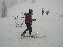
A quick test hole revealed the snow pack to be about 3 feet deep, a lot of melting had occurred recently from warm temperatures and it showed. Skinning up from where the Montgomery Pass trail started was hard work. A combination of the altitude, my out-of-shapeness and the inefficiency of my telemark set-up made the going slow and a little painful. After leaving my car 2 hours earlier from Cameron Pass, I arrived at Montgomery Pass to a serious wind storm.

A front was clearly moving in, bringing snow and lots of cold temperatures, woohoo! I quickly changed my cold, damp layers to dry, warm ones. It was amazing because down at Cameron Pass (1,000 feet lower), there was hardly any wind at all. I love how much better things get at altitude (-;

I did not go all the way to the official "Montgomery Pass" due to time and weather concerns. What happened was I looked at the time on my phone, still being in EST, I mistakenly thought it was 16:45 instead of 14:45 and since the weather seemed to be worsening I headed down quickly. I was perhaps a 5 minute stroll from the pass though, nonetheless I am a bit disappointed in myself. I did stop just beyond the pass winds to eat a sandwich and chocolate as well as drink some water. Thats where it hit me how serenly magnificent mountain areas are, an ecosystem that thrives in an environment that is inherently unforgiving.
The ski descent was a little treacherous. The narrow trail leading up required quick and precise tele-turns, they were tough on my tired legs. Looking back I wish I had skied the bowls up there, but by myself, without an avalanche beacon and without current snow pack knowledge it could have been my demise, instead of paperwork that is (-;
No comments:
Post a Comment