Wednesday, January 28, 2009

Cross-country trip: phase 2

For phase 2 of my journey to California I embarked from the Cameron Pass area of north-central Colorado. Although the beginning of my journey was at night, I got to see quite a lot of majestic mountains in Nevada. Before this trip, I had no idea Nevada had so many peaks!

The drive from the Pudre Canyon in Colorado to Salt Lake City was really a long one, perhaps too large of an undertaking in fact. I first drove north to Laramie, Wyoming to pick up I80. Laramie is the home of Wyoming State University and also is the highest college campus in the continental USA at 7,200 feet, nice and high (-; Coming into Laramie the snow was blowing unbelievably hard and the flakes were as big as cotton balls, making driving slow and tedious.

Nearly the entire way to Salt Lake City on I80 from Laramie was snowy. What should have taken a 7 hour trip, took nearly 9 hours and arrived in Salt Lake at about 3:30am. The next day I slept in and rested at the Marriott Courtyard, a lovely accommodation. I awoke at 5:15am the next morning to 3-4 inches of snow in Salt Lake. Until driving perhaps 1-2 hours outside of Salt Lake the driving was slow and treacherous. I was sharing the road with really only big trucks and to pass them in the snowy/icy left lane was rather unnerving. Once again during my trip, I wish I was wearing a set of good snow tires.

Passing through western Utah was suuper windy, with periods of blowing snow that only allowed sight distance of about 100 feet or less. With the sunrise came a break in the weather and dry, but cold conditions. Crossing into Nevada, I stopped a cool truck stop cafe in Wells for breakfast. The range outside of the truck stop looked like this:

All the slot machines were a surprise at the entrance to the cafe, but the delicious breakfast and wonderful service allowed me to keep moving. As I passed through Nevada, I attempted to take some photos of the countryside as I drove and I think they came out pretty well:


The above photo is entering Nevada (pretty much). It is quite interesting to identify the snow line, below I reckon it is about 6,000 feet.

A cool massif.

Unfortunately as I went through Reno and into California it got really crowded on the highways and so I could not take anymore road shots. Lake Tahoe was beautiful and full of snow, but surprisingly low on elevation. It must be their proximity to the ocean and perhaps lake-effect that gives Tahoe its special snow. Descending into the Bay Area near Sacramento was amazing. The ecosystem changed so rapidly that one moment I am in a coniferous, snowy forest and next I see heaps of palm trees! Only in California...
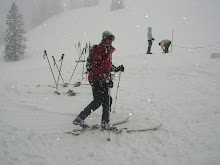
Cameron Pass ski tour

A big reason for my stopping in Colorado during my cross country trip to California was to make ski tours. I absolutely love ski touring, the thigh-burning brutal ascent and the harrowing descent, as well as the novel experience of just being high in altitude. During the week, my friend Tyler (whom I was staying with in Fort Collins) had courses to attend. So I decided to head up to Cameron Pass from Fort Collins, a 70 mile or so trip one way and about 1.5 hours. It is amazing the changed landscape that you incur along this trip, from nearly desert to sub-alpine wonderland.

I checked out the 2 trail heads from Cameron Pass and decided to take the Cameron Connection to Montgomery Pass trail. A round-trip of about 8 miles I reckon. The first 2 miles were modest rolling hills, but at 10,000 ft. the going was slow until I acclimated better. Along the Cameron Connection:


A quick test hole revealed the snow pack to be about 3 feet deep, a lot of melting had occurred recently from warm temperatures and it showed. Skinning up from where the Montgomery Pass trail started was hard work. A combination of the altitude, my out-of-shapeness and the inefficiency of my telemark set-up made the going slow and a little painful. After leaving my car 2 hours earlier from Cameron Pass, I arrived at Montgomery Pass to a serious wind storm.


A front was clearly moving in, bringing snow and lots of cold temperatures, woohoo! I quickly changed my cold, damp layers to dry, warm ones. It was amazing because down at Cameron Pass (1,000 feet lower), there was hardly any wind at all. I love how much better things get at altitude (-;


I did not go all the way to the official "Montgomery Pass" due to time and weather concerns. What happened was I looked at the time on my phone, still being in EST, I mistakenly thought it was 16:45 instead of 14:45 and since the weather seemed to be worsening I headed down quickly. I was perhaps a 5 minute stroll from the pass though, nonetheless I am a bit disappointed in myself. I did stop just beyond the pass winds to eat a sandwich and chocolate as well as drink some water. Thats where it hit me how serenly magnificent mountain areas are, an ecosystem that thrives in an environment that is inherently unforgiving.

The ski descent was a little treacherous. The narrow trail leading up required quick and precise tele-turns, they were tough on my tired legs. Looking back I wish I had skied the bowls up there, but by myself, without an avalanche beacon and without current snow pack knowledge it could have been my demise, instead of paperwork that is (-;

Tuesday, January 27, 2009

San Francisco Autobahns

It is unbelievable driving around the Bay Area! If you think where you drive is bad, multiply it times 10 and you get this part of California! I grew up in the metro Washington DC area, have driven around other numerous big cities, including New York and nothing prepares you for here. We're talkin extremely short merge lanes from a 20mph curve into a 65mph race track! I mean we got people flooring it in these big trucks/SUVs with disgustingly huge payloads that never get used, little imports zipping around like it is a race, and everyone changing lanes like its cool or something.

Although I must sat, it is nice that there is such a comprehensive freeway (excuse me, I meant to say HIGHWAY as we say in the east) system to get really anywhere relatively quickly. I am just amazed at the amount of infrastructure adjustment for such a road system. I would wager to say 1/4 to 1/3 of the human-used space is devoted to roads around here. That is such an extraordinary amount of space! Imagine if everyone's marriage to their automobile was divorced by public transport, you'd get soo much more usable space! It is interesting to see the layout too, clearly a lot of engineering went into their system. The key to road planning is to keep cars always moving, stop-and-go uses the most fuel and causes more wear and tear.

If you haven't been keeping up in the news lately, President Obama has been talking about California's lead in the environmental movement. One thing CA is proposing is much stricter fuel economy standards for vehicles sold here, about a dozen other states are posed to follow suit if it goes through. The hang-up is the EPA which refuses to allow states to impose their own regulations, which turned down CA's appeal for better standards during Bush's term. President Obama is pressuring the EPA to allow it to happen and the automakers are crying (expensive, we can barely sell cars etc...)- it is time they got their act together and especially when they are using MY money to do it! I like that there is more to look forward to in terms of environmentalism in CA as well.

Now that that is off my back I feel much better now. Is it me, or do Californians just love to drive horizontally?

Sunday, January 25, 2009

Snow camping

For the past few years I've made a conservative effort to come out to Colorado in the winter time to camp out in the snow. There really is nothing else like it, just you and nature in a surreal, quiet dormancy. However, it is worth noting that there is an extraordinary process behind camping in the cold, I think the amount of time preparing for winter camping rivals the time spent out there (-; No matter how hard you try to keep everything dry, wetness from the snow seeps in everywhere. Whoever can invent a way to dry things out while camping in the snow will be a millionare.


This year I helped Tyler work on a more permanent snow cave up near Cameron Pass in the Pudre Canyon on north-central Colorado. He picked a great location, tucked away in an alcove valley between a summer use road and highway 14 (Pudre Canyon Highway). Situated at 9,200 ft. and facing north, the snow pack near the cave is nice and deep, as evidenced by the fire Tyler built:

Shortly after this photo was taken, we cut blocks out of the hard-packed snow and made the entrance much narrower. To make blocks, one must first find suitable snow and cut them out with a small-toothed saw. Snow blocks are brilliant building materials when made properly and essentially are the basis for igloos made by the Eskimo. Often, sutiable snow is difficult to find, so one must pack it down with snow shoes. The best place to look is the leeward side of trees on the edge of a clearing, where the snow has drifted. Game trails are often nearby, good place to set some snares for snowshoe hares.

I am sure you are wondering how gear is brought from the car to the igloo, well with childrens' play sleds! A rope is tied to the sled and to ourselves and the sled is dragged:

Yes, that is a snowboard attached to Tyler's rucksack.

You might be wondering, how do you keep yourself off the snow when you sleep? The key is to put as many layers and air space between you and the cold snow/ground as possible. In our shelter a tarp was put down first to cover the entire floor, then closed-cell foam pads, then (in my case) a Slumberjack self-inflating air mattress, a Z-rest closed-cell foam pad and finally a fleece blanket wrapped around the whole package. As you can tell, that is a lot of layers! A surprisingly large amount of heat is lost through your back while you sleep though.

You also might be wondering, what about keeping warm when not in the sleeping bag? Well, you stay moving around! That is why we dress in layers, allow me to elaborate. The layer closest to your skin is called the base layer, it is typically a high-performance, thing layer that acts to wick away moisture from your body to the next layer. The next layer is also synthetic and serves to keep pulling the moisture to your outer layer, this layer is typically fleece, but wool is also suitable. The last layer is usually the shell, serving to repel moisture, but yet allow some perspiration to get outside (hance Gore-tex). In essence, the key is to always be dry, because; dry = warm! NEVER wear cotton products, they do not keep you warm when you get wet!


A final departing shot of us packing the cars, Tyler back to Fort Collins and me to California (I drove through some nasty snow all the way to Salt Lake City, to arrive at 3:30am!). The plowed snow bank behind the cars is bigger than it looks! It took me an hour to get out of there, Tyler finally had to pull me with my tow strap! The whole time I had snow wires in my trunk, DUH! Oh well, you live and you learn. This blog was no where near a comprehensive winter camping guide, if you do have questions feel free to post a comment.

Cross-country trip: phase 1

I know there has been an absence of blogs lately, so I will try and remedy that, I’ve just been too stinkin busy having fun in Colorado (-: I arrived a bit less than a week ago in Fort Collins to spend time with my friend Tyler and to help him with his snow igloo. He enjoys snow camping as much as I do and we have been able to get out for 2 excursions so far, but more on that later.


I embarked from West Virginia a week ago where temperatures were unbelievably cold, -5 F! It was so cold on the morning I left, when I opened my trunk of my Volvo, the struts that hold the lid up failed! I was very sad to leave my girlfriend, who has a semester remaining at WVU to finish her program. I had to leave my sister too, saying goodbyes is always difficult. I drove with a furiousness up through PA, and then into northwest Ohio where I encountered lots of lake-effect snow around the Toledo area. A quick application of the brakes, some gas pumping and a re-setting of the GPS navi (her name is Maggie) and I was in Indiana for another tank of gas.


The first days drive was pretty easy until I got on I80 in Iowa, which was an enormous yard sale of hundreds of cars that slipped off the roads and were stuck in snowbanks. The problem wasn’t the snow falling, but the snow that was relentlessly blowing in from the plains/fields and keeping the road slicked up. I took my time and pulled into Des Moines, Iowa around 11pm after leaving Morgantown, WV at 7:30am.


This first days drive I had a mascot, a pretty silly one indeed, but it reminded me of Madison (-;

Not much can be said about the 2nd days drive through western Iowa and the unbelievably wide state that is Nebraska. It was fun watching the altimeter traveling west because Nebraska is one big hill and by the time I hit the Wyoming border and Cheyenne it was 6,000 ft, pretty damn cool. I do love being at altitude (-:

Sunday, January 4, 2009

Beartown and Hills Creek Falls, WV

This past weekend I had the distinguished opportunity to visit Wild and Wonderful West Virginia. I was there for a relaxing business trip and to stay with Madison's family in lovely Lewisburg. Lewisburg is located in Greenbrier County in the south eastern part of the state and a mere 16 miles to the VA border. The landscape consists of rolling hills, sparse pepople and a quaint historic district.

Yesterday, we drove up into adventurous and remote Pocahontas County, immeadiately to the north of Lewisburg. Driving amongst sweeping hillsides, lonely farmhouses and finally a higher-elevation forest of Mononghalia National Forest. It was especially tantalizing because the snow got deeper the higher we went (-; First stop was Beartown, a unique collection of slowly eroding boulders perched high on plateau. I have been told that the combination of high elevation, lack of direct sunlight and landscape allow snow or ice to occur late into summer!


The boardwalk was not so long, but it wound its way throughout the boulders, providing a slightly different scene around each corner.


After spending an hour walking around the neat boardwalk constructed throughout the state park, we embarked for Hills Creek Falls. We pulled into a seemingly ominous parking lot sugar coated with 1-2 inches of snow. I was expecting to hear the falls immediately, but a short hike revealed the first Upper Falls. The Upper and Middle Falls were not so impressive, but the Lower Falls, at 63 feet were pretty neat!

I have been told that on some years the entire falls are frozen over, I think we came a bit too early in the year (-;

Friday, January 2, 2009

High alpine protection forests

It is well known high alpine areas are magnificent places to visit, work and even live in. Increased pressure from tourism and general infrastructure infringement place these fragile alpine ecosystems at risk. Mountain valley settlements are at risk of a variety of mountain disasters, including avalanches, torrents, rockfall and other erosion processes. Forests can serve a vital protective function in higher areas previously bare and susceptible to the extremes of the alpine environment.

These "protective forests" are typically managed to provide continuous and passive protection (P. Brang). When natural disturbances occur, the disturbances drastically affect how well a protective forest can function. I suppose it is worth elaborating a bit into the functions a protective forest can have, simply because they are often in place and we take them for granted. Forest soils in rugged mountain areas are often shallow and a forest keeps it in place. Precipitation is taken up and let out slowly, filtering the water for drinking, replenishing the ground water and preventing slope movement from occurring. Many alpine human habitats simply rely heavily on the stabilization characteristics that protective forests provide.

As lovely as protective forests seem, they are a fragile resource. Storms topple trees quickly, allowing a bark beetle outbreak to occur, threatening the surrounding trees and predisposing the area to develop an even larger gap. Avalanches and snow gliding may prevent trees from growing at all or severely crippling them. I will note that the alpine areas are very unforgiving to trees to begin with. A short growing season, cold temperatures and strong winds, and a long residual snow cover that breeds fungal pathogens all work hard against struggling tree seedlings.

We cannot change the climate occurrences, but we can help to maintain existing protective forests, promote new ones and construct measures for short-term hazard mitigation. Silvicultural practices to encourage the growth of seedlings, snow movement prevention and proper planting practices all help immensely. Most important of all, more people need to be educated on the widespread benefits of protective forests, including their risk mitigation abilities. What I would love to see is the designing of forests based on ecosystem function, like a forest designed for water filtration for instance. We could apply that concept to nearly any area...